Crie uma GUI para a previsão do tempo usando a API openweathermap em Python
Pré-requisitos: Encontre o clima atual de qualquer cidade usando a API openweathermap
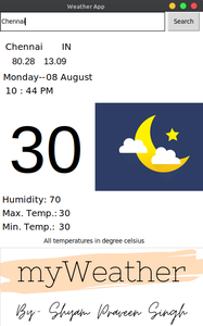
A ideia deste artigo é fornecer um aplicativo GUI simples aos usuários para obter a temperatura atual de qualquer cidade que desejam ver. O sistema também fornece uma interface de usuário simples para simplificar a aplicação. Ele também fornece uma UX incrível para seus usuários. As características deste aplicativo serão que ele será um aplicativo de previsão do tempo em tempo real que retorna a temperatura atual, temperatura máxima e mínima, umidade, latitude e coordenadas de longitude da cidade pesquisada, data atual e hora. Também pode alterar o tema de acordo com a hora do dia.
API Openweathermap
openweathermap é um serviço que fornece dados meteorológicos, incluindo dados meteorológicos atuais, previsões e dados históricos para os desenvolvedores de serviços da web e aplicativos móveis.
Módulos Necessários
- Tkinter: É a maneira mais rápida e fácil de criar aplicativos GUI. Isso está incluído nos módulos padrão do Python , portanto, não há necessidade de instalá-lo externamente.
- PIL: PIL é a biblioteca de imagens Python que fornece ao interpretador python recursos de edição de imagens.
- json: Este módulo é usado para lidar com arquivos JSON e vem integrado com o Python. Portanto, não há necessidade de instalá-lo externamente
- solicitações: é usado para fazer solicitações HTTP a um URL especificado. Este módulo não vem embutido com Python. Para instalá-lo, digite o comando abaixo no terminal.
pedidos de instalação pip
Imagens usadas no aplicativo abaixo:

moon.png

sun.png
logo.png
Abaixo está a implementação.
fromtkinterimport*importrequestsimportjsonimportdatetimefromPILimportImageTk, Imageroot=Tk()root.title("Weather App")root.geometry("450x700")root['background']="white"new=ImageTk.PhotoImage(Image.open('logo.png'))panel=Label(root, image=new)panel.place(x=0, y=520)dt=datetime.datetime.now()date=Label(root, text=dt.strftime('%A--'), bg='white', font=("bold",15))date.place(x=5, y=130)month=Label(root, text=dt.strftime('%m %B'), bg='white', font=("bold",15))month.place(x=100, y=130)hour=Label(root, text=dt.strftime('%I : %M %p'),bg='white', font=("bold",15))hour.place(x=10, y=160)ifint((dt.strftime('%I'))) >=8&int((dt.strftime('%I'))) <=5:img=ImageTk.PhotoImage(Image.open('moon.png'))panel=Label(root, image=img)panel.place(x=210, y=200)else:img=ImageTk.PhotoImage(Image.open('sun.png'))panel=Label(root, image=img)panel.place(x=210, y=200)city_name=StringVar()city_entry=Entry(root, textvariable=city_name, width=45)city_entry.grid(row=1, column=0, ipady=10, stick=W+E+N+S)defcity_name():api_request=requests.get("https://api.openweathermap.org/data/2.5/weather?q="+city_entry.get()+"&units=metric&appid="+api_key)api=json.loads(api_request.content)y=api['main']current_temprature=y['temp']humidity=y['humidity']tempmin=y['temp_min']tempmax=y['temp_max']x=api['coord']longtitude=x['lon']latitude=x['lat']z=api['sys']country=z['country']citi=api['name']lable_temp.configure(text=current_temprature)lable_humidity.configure(text=humidity)max_temp.configure(text=tempmax)min_temp.configure(text=tempmin)lable_lon.configure(text=longtitude)lable_lat.configure(text=latitude)lable_country.configure(text=country)lable_citi.configure(text=citi)city_nameButton=Button(root, text="Search", command=city_name)city_nameButton.grid(row=1, column=1, padx=5, stick=W+E+N+S)lable_citi=Label(root, text="...", width=0,bg='white', font=("bold",15))lable_citi.place(x=10, y=63)lable_country=Label(root, text="...", width=0,bg='white', font=("bold",15))lable_country.place(x=135, y=63)lable_lon=Label(root, text="...", width=0,bg='white', font=("Helvetica",15))lable_lon.place(x=25, y=95)lable_lat=Label(root, text="...", width=0,bg='white', font=("Helvetica",15))lable_lat.place(x=95, y=95)lable_temp=Label(root, text="...", width=0, bg='white',font=("Helvetica",110), fg='black')lable_temp.place(x=18, y=220)humi=Label(root, text="Humidity: ", width=0,bg='white', font=("bold",15))humi.place(x=3, y=400)lable_humidity=Label(root, text="...", width=0,bg='white', font=("bold",15))lable_humidity.place(x=107, y=400)maxi=Label(root, text="Max. Temp.: ", width=0,bg='white', font=("bold",15))maxi.place(x=3, y=430)max_temp=Label(root, text="...", width=0,bg='white', font=("bold",15))max_temp.place(x=128, y=430)mini=Label(root, text="Min. Temp.: ", width=0,bg='white', font=("bold",15))mini.place(x=3, y=460)min_temp=Label(root, text="...", width=0,bg='white', font=("bold",15))min_temp.place(x=128, y=460)note=Label(root, text="All temperatures in degree celsius",bg='white', font=("italic",10))note.place(x=95, y=495)root.mainloop()
Resultado:
As postagens do blog Acervo Lima te ajudaram? Nos ajude a manter o blog no ar!
Faça uma doação para manter o blog funcionando.
70% das doações são no valor de R$ 5,00...

Diógenes Lima da Silva